
Colorado
![]()
Type |
Symbol |
Year Est. |
|---|---|---|
State Rock |
Yule Marble |
2004 |
State Mineral |
Rhodochrosite |
2002 |
State Gemstone |
Aquamarine |
1971 |
State Fossil |
Stegosaurus |
1982 |
State Rock: Yule Marble
HB04-1023
AN ACT CONCERNING THE DESIGNATION OF YULE MARBLE AS THE STATE ROCK.
Be it enacted by the General Assembly of the State of Colorado:
SECTION 1. Part 9 of article 80 of title 24, Colorado Revised Statutes, is amended BY THE ADDITION OF A NEW SECTION to read:
24-80-912.7. State rock. Yule Marble is hereby made and declared to be the state rock of the state of Colorado.
Marble is a metamorphosed variety of the sedimentary rock limestone. This means that the original sedimentary rock underwent periods of increased temperatures and pressures to change the rock itself. The primary minerals in marble are calcite (CaCO3) or dolomite ((Ca,Mg)CO3) but it will usually have other mineral contaminates mixed in as well (i.e., clay, mica, quartz, pyrite, and iron oxide, etc.). Since, the primary mineral in marble is calcite, most marbles will have a white color with swirls of darker colors (the contaminates) but marbles can be found in many different colors depending on what impurities were present in the initial limestone. During metamorphism of the original limestone, the calcite is recrystallized to form interlocking crystals, which will usually destroy any remnants of the original rock, including any fossils present.

The unique feature of the Yule Marble, found near the town of Marble, Colorado, is that the marble is one of the purest marbles ever quarried (meaning it lacks most of those impurities). For this reason it was chosen as the decorative stone on the Lincoln Memorial in Washington DC. The Yule Marble started out as the dark-blue Mississippian age Leadville Limestone. During the Tertiary, parts of the Leadville Limestone underwent contact metamorphism along the edges in contact with the uplifted granitic Treasure Mountain dome. After recrystallization, the Leadville Limestone was metamorphosed into the distinctive white marble known today. Along with the Lincoln Memorial, Yule Marble has been used for the Tomb of the Unknown Soldier, which was the largest single piece of marble ever quarried at the time. They also supplied some of the national cemetery headstones. However due to problems financing and running the mine, not many other notable uses have been made of the Yule Marble.
Related: Alabama State Rock - Marble; Vermont State Rock #2 - Marble
State Mineral: Rhodochrosite
HB02-1346
AN ACT CONCERNING THE DESIGNATION OF RHODOCHROSITE AS THE STATE MINERAL.
Be it enacted by the General Assembly of the State of Colorado:
SECTION 1. Part 9 of article 80 of title 24, Colorado Revised Statutes, is amended BY THE ADDITION OF A NEW SECTION to read:
24-80-912.5. State mineral. Rhodochrosite is hereby made and declared to be the state mineral of the state of Colorado.
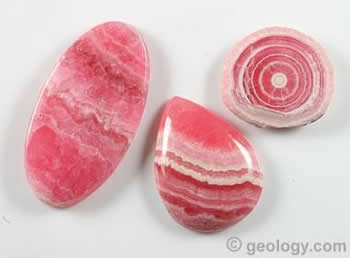
Rhodochrosite is a manganese carbonate mineral (chemical formula (Mn, Fe, Mg, Ca)CO3) with a light pink to bright red color. As you can see with the chemical formula the manganese is frequently replaced with other elements like iron, magnesium, and/or calcium. These substitutions present problems with providing definitive mineral properties since the substitutions cause the specific gravity, hardness, and color of the mineral to vary. Generally though, rhodochrosite has a hardness of 3.5-4 with 3 directions of perfect, rhombohedral cleavage. Rhodochrosite is often found in association with silver mines and is sometimes mined as a by-product in those mines. Rhodochrosite can also be found filling the veins and fractures within metamorphic rocks. In this instance, the minerals are often built up over time with separate mineralization events, each one possibly producing different shades of pink within the mineral. Rhodochrosite can be used as a manganese ore, however there is often not enough of it when found to make it economically viable. Since rhodochrosite is so soft, its use in even jewelry is limited, where it usually ends up being used just as a natural mineralogical sample.
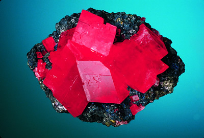
Rhodochrosite crystals with tertahedrite from the Sweet Home Mine, Alma, Colorado. Image courtesy of the Colorado Geological Survey.
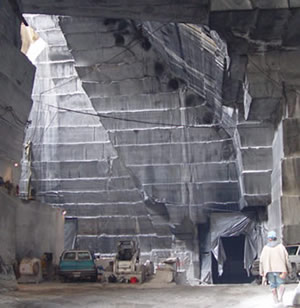
Rhodochrosite, is extremely rare in well-formed crystals. That is the reason that the Sweet Home Mine, near Alma, Colorado is so unique (such as the sample to the right). This is one of the few mines in the world to produce specimen quality rhodochrosite samples. Formerly a silver mine that opened in 1873, the mine was leased to a rhodochrosite company who started excavating high grade rhodochrosite samples. They mine by blasting holes in the rock that are 2mx2mx2m, and continue the process forming tunnels. Once a potential rhodochrosite pocket is located, special tools are brought to carefully extract the specimens, where they are then taken to be cleaned and prepared for sale. The usually pink color, as seen in the image to the upper left, is not the only variety seen in Colorado samples. Colorado rhodochrosite also comes in a translucent red crystal variety that is recognized worldwide for its beauty (as seen in the image to the right). Beyond just the Sweet Home Mine, rhodochrosite can be found in 18 counties within Colorado, with the largest rhodochrosite crystal ever found, the 6.5 inch Alma King, being found within the Sweet Home Mine itself.
State Gemstone: Aquamarine
Chapter 325
An Act concerning state emblems, and providing for the designations of a state gemstone.
Be it enacted by the General Assembly of the State of Colorado:
Section 1. Article 8 of chapter 131, Colorado Revised Statutes 1963, as amended, is amended BY THE ADDITION OF A NEW SECTION to read:
131-8-12. State gemstone. The aquamarine is hereby made and declared to be the state gemstone of the state of Colorado.
L. 71: p. 1221, § 1. C.R.S. 1963: § 131-8-12.
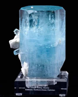
An aquamarine crystal from the Shiga Valley of northern Pakistan. Image courtesy of Arkenstone, geology.com, and iRocks.com.
Aquamarine is a greenish blue variety of beryl (Be3Al2Si6O18), named for the seawater in which it looks like. It has a hardness of 7.5-8 and often forms perfect, six-sided prismatic crystals. Although it can be found in duller colors; when heated to very high temperatures the mineral attains its characteristic sky-blue color. Even though beryl, and therefore aquamarine, has a very high hardness, its uses seem to be generally limited to jewelry and display items. Crystals of aquamarine are relatively common, however they still demand a high price, due to this intrinsic beauty of the specimens. Display quality aquamarine crystals can be found in Brazil, Pakistan, China, Russia, Myanmar, as well as several localities within the United States, among other localities worldwide. Quality aquamarine specimens within the US can be found in Colorado, California, Idaho, Connecticut, and Massachusetts.
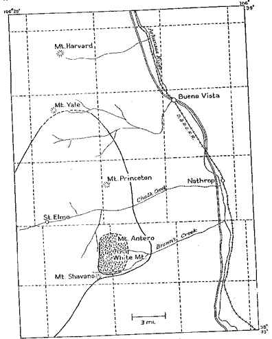
The location of the Tertiary Princeton batholith near Mt. Antero and White Mt. where the aquamarines in Colorado have been mined. Map courtesy of Switzer. 1939.
Prospecting for aquamarine began in the late 1800's in the Mt. Antero area of Colorado. Many aquamarine crystals have been found in vugs (holes) within granite pegmatites of the Tertiary Princeton batholith. There are several different types of pegmatites within this region, with two different beryl pegmatites, only one of which contains vugs, or pockets. It is this pegmatite that is the most economically viable for aquamarine specimens. These vuggy beryl pegmatites include not only aquamarine crystals but also crystals of other minerals like microcline, smoky quartz, albite, and fluorite. The veins and pegmatites where the aquamarine has been found are mostly contained within an area roughly 3 miles across; an area that contains the summits of Mt. Antero and White Mt. (as seen in the map to the right). These pegmatites formed at temperatures that ranged from 200°C up to 600°C. Other areas within Colorado that also contain quality aquamarine specimens include Mt. Baldwin and Mt. Princeton, which are both located nearby to White Mt. and Mt. Antero.
State Fossil: Stegosaurus
Executive Order D0002 82
ESTABLISHING THE STEGOSAURUS AS THE STATE FOSSIL
WHEREAS, Colorado enjoys a long and colorful history which extends well into the prehistoric era in which numerous dinosaurs and other now-extinct flora and fauna flourished; and
WHEREAS, the Stegosaurus lived in Colorado 150 million years ago in the Mesozoic era during the Jurassic period; and
WHEREAS, there are only six skeletons of the Stegosaurus on public display in the United States, including one on public display at the Museum of Natural History in Denver, Colorado, which was found and dug up by a teacher and students at Canon City High School; and
WHEREAS, the Stegosaurus, like all dinosaurs, makes a continuing contribution to modern living through fossil fuels which are comprised of the remains of dinosaurs and other once-living matter from prehistoric times; and
WHEREAS, the Stegosaurus has stimulated the interest of numerous Colorado school children to participate in the political process through their efforts to have the Stegosaurus established as a state fossil by the Colorado General Assembly; and
WHEREAS, three other states have established state fossils; and
WHEREAS, the establishment of a state fossil for the State of Colorado would be a benefit to the tourism industry of the state and would provide a positive conclusion to the important effort of numerous school children in Colorado to participate in our political process;
NOW, THEREFORE, I, Richard D. Lamm, Governor of the State of Colorado, pursuant to the authority vested in me under the laws and constitution of the State of Colorado, DO HEREBY declare that the Stegosaurus shall be considered the State Fossil for the State of Colorado and shall remain as the State Fossil pursuant to this Executive Order until such time as the General Assembly takes action to establish a State Fossil by statute.
GIVEN under my hand and the Executive Seal of the State of Colorado, this 28th day of April, A.D., 1982.
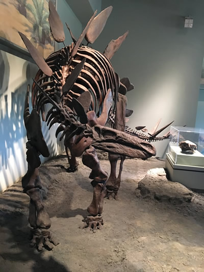
Stegosaurus at the Field Museum, Chicago, IL. Photo by Jim Lehane
Stegosaurus was one of the earliest dinosaur finds during the infamous Cope and Marsh Bone Wars (find out more about that here). The first Stegosaurus fossils were discovered in 1876 in the Morrison Formation of Colorado by M.P. Felch and were named by Marsh in 1877. The original fossils were discovered north of the town of Morrison, CO. The name Stegosaurus means roof lizard, a name that goes back to when Marsh first described the animal thinking that the plates laid flat along its back, creating a roof. It wasn't until Marsh discovered another example of Stegosaurus with the plates still in situ (in place) that he realized his mistake. About 80 specimens of Stegosaurus have since been discovered in the Morrison formation, stretching from Colorado to Wyoming.
Stegosaurus was an herbivore, that lived about 150 million years ago during the Jurassic period. The animal is most well known for the twin row of bony plates that lined its back and a set of spikes on its tail. Scientists are not certain of the use of the plates and several theories have been postulated including defense, display, or even heating/cooling pads (blood vessels ran through the plates allowing the air/sun to heat or cool the plates as needed); however it is pretty universally accepted that the spikes at the end of the tail were for defensive purposes. One of the most commonly known "facts" about Stegosaurus was that it had a very small brain for the size of the animal (it is about the size of a bus, 30 ft in length, with a brain the size of a hot dog). Because of the comparably small size of the brain, scientists at one time thought that Stegosaurus must have had a second "brain", or nerve ball cluster, that operated as a second brain somewhere along the spinal column. This idea came from the discovery of an enlarged canal along the pelvic region, however this theory has since been rejected by scientists. Stegosaurus had a toothless beak, with rounded peg-like teeth further back in its mouth, and a weak jaw, so it likely ate low lying plants like ferns and cycads.
References
https://statesymbolsusa.org/states/united-states/colorado
https://www.colorado.gov/pacific/archives/symbols-emblems
http://geology.com/rocks/marble.shtml
https://pubs.usgs.gov/pdf/bulletin/b2162/b2162.pdf
http://geology.com/minerals/rhodochrosite.shtml
https://www.collectorsedge.com/t-sweethome.aspx
http://coloradogeologicalsurvey.org/education/state-symbols/state-mineral/
http://www.minerals.net/mineral/aquamarine.aspx
http://geology.com/gemstones/states/colorado.shtml
http://www.minsocam.org/MSA/collectors_corner/arc/comtantero.htm
http://www.the-vug.com/vug/collectors_edge_lees_collection.html#.WCX3JGorKHs
https://geology.com/minerals/beryl.shtml
http://www.livescience.com/24184-stegosaurus-facts.html
http://www.ereferencedesk.com/resources/state-fossil/colorado.html
https://ansp.org/exhibits/online-exhibits/stories/bone-wars-the-cope-marsh-rivalry/
http://www.nhm.ac.uk/discover/dino-directory/stegosaurus.html
https://www.livescience.com/24184-stegosaurus-facts.html
https://leg.colorado.gov/sites/default/files/images/olls/2004a_sl_24.pdf
https://leg.colorado.gov/sites/default/files/images/olls/2002a_sl_102.pdf
https://lawcollections.colorado.edu/colorado-session-laws/islandora/object/session%3A17090
https://spl.cde.state.co.us/artemis/goserials/go3813internet/go381319820002internet.pdf
Geology of Colorado's National Parks
Through Pictures
(at least the one's I have been to)
Black Canyon of the Gunnison National Park
Black Canyon of the Gunnison National Park
Visited in 2015
A random trip down to Colorado last year brought us to Black Canyon of the Gunnison. A park that perhaps is as magnificent a canyon as the Grand Canyon, although not nearly as wide. Unfortunately I seem to have not gotten a picture of the entrance sign (I know, I don't know how it slipped by me either). So we will just go on with the regular park pictures. I definitely recommend clicking on these to blow them up. We decided to camp at the park, however the park is very straightforward. One road in and through the park, that same road you turn around on and head out.
.jpg)
View of the canyon along the Rim Rock Trail, between the campground and the visitor's center.
.jpg)
A view down the canyon from up on the rim. The majority of the rocks that make up the canyon walls are Precambrian Gneiss. The reason that the canyon is so deep, it is believed, is because of a similar event that happened at the Grand Canyon. The land surface was pushed upwards quickly, causing more down cutting in a river that was already entrenched. However, since gneiss is much harder than the softer sedimentary rocks of the Grand Canyon, the canyon here was cut deeper with walls that ran more vertical.
.jpg)
A view of the canyon from the Visitor's Center area.
.jpg)
Another view of the canyon. You can catch a slight glimpse of the river in the middle of the picture, emphasizing the depth of the canyon.
.jpg)
Across the canyon.
.jpg)
This is the "Painted Wall". The pink veins are igneous intrusions that formed pink pegmatite within the overall gneiss.
.jpg)
Down the canyon walls.
.jpg)
More canyon views.
.jpg)
Straight down. The walls really are near vertical in most areas of the canyon.
.jpg)
Down the canyon.
.jpg)
And since I have no entrance sign photo, here is a shot of one of our camping companions, not wanting to get out of her tent.
Visited in 2020
Colorado National Monument is a park we had driven near a few times but never actually gone to before now, not realizing how truly beautiful it was. The overlooks are simply astounding and everything about the park screams geology. It is directly outside Grand Junction and Fruita, Colorado and is a quick jump from either of those cities in SW Colorado.
.jpeg)
The western entrance to Colorado National Monument.
.jpeg)
Colorado National Monument is an interesting park. Most of the park is located on top of a high cliff that looks out over the Grand Valley where Fruita and Grand Junction are located. The reason for the high cliff is that the park resides on the upturned side of a giant fold. Within geology as a whole, there are several different types of folds within rock units. The most common folds are the syncline, when the rocks are bent like a "U", and the anticline, where the rocks are bent the other way like an "A". The Colorado National Monument fold is a different type of fold though, known as a monocline, where only one edge of the fold is bent. It's like an anticline with only half of the "A" is bent. You can see the cross section of rocks within the fold and the park. The oldest rocks of the fold are those located near the valley floors, which are the Upper Triassic age Chinle Formation (~200 million years old). The rock units progressively get younger until you get to the top layer of the fold, represented by the Cretaceous age Dakota Sandstone (~100 million years old). You can see the rocks in this park cover a large span of time. Image from the Rock Layers of the Monument brochure from the NPS.
.jpeg)
View of Independence Rock from Otto's Trail. Within these large formations here we have a series of rocks. The base of the valleys are the really old rocks. Below the Chinle Formation described above is some Precambrian metamorphic rocks called the Black Canyon Group. These include gneiss, dark schists, and light pegmatites, which are all extremely hard, erosion resistant rocks. The Black Canyon Group is estimated to be 1.7 billion years old. The erosion resistance of these rocks are what caused the erosion of the valleys to essentially stall once it reached this level, unable to erode very quickly through the metamorphic layer.
.jpeg)
Here is a view at the end of Otto's trail looking north towards Fruita in the distance. Immediately on top of the Black Canyon Group is the Chinle Formation. Between them is a gap in time equal to 1.5 billion years. This gap in time is known as an unconformity, specifically a nonconformity, where the rocks that used to be here were eroded away before the newer rocks were deposited later. These newer rocks are the 200 million year old Chinle Formation. The Chinle Formation is comprised of red mudstones, shales, conglomerates, and thin limestones. Shales and mudstones are all extremely easy to erode, so they typically form smooth slopes when eroded. That is what you see at the base of the cliffs, where the tree line starts. The Chinle Formation extends from the tree line down to about where the underlying red soil stops. The Chinle Formation was deposited in a stream and floodplain environment.
.jpeg)
Here is a view from a little further down the main road at Grand View. I love these types of stops because they provide a display with the geology overlaid on the rocks as you see them. A picture of the geology sign is directly below to compare. Directly above the Chinle Formation is where the cliffs start. This is the Wingate Sandstone. The Wingate is a very thick bed of dune sandstone from a prehistoric desert deposited during the Lower Jurassic. Most of the geologic formations within this park are located within the Wingate.
.jpeg)
The Wingate continues up until a slight color change in the rocks can be seen near the top of the cliff. The rocks on the very top here are more grey in color than the yellow of the Wingate. This is the Kayenta Formation, another sandstone but with more shale and conglomerate mixed in. The Kayenta Formation represents a period of time when the environment started to bounce back from the Wingate desert and rains started to fall a bit more.
.jpeg)
Here is a view from the Grand View looking back towards the cliff edge. You can see here the next series of rock units above the Kayenta Formation. This is the Entrada Sandstone, seen here most clearly on the right hand portion of the photograph as the smooth yellow sandstone cliff face just below a thin strip of green plants at the top of the rock series. The Entrada Sandstone is a Middle Jurassic aged sandstone (~150 million years old) that was deposited from the dunes of a nearby sea. This is the same rock formation that the arches are from at Arches National Park.
.jpeg)
View from the Grand View looking towards the north at Fruita.
.jpeg)
Here is a closer look at the Entrada Sandstone where we can just barely make out the next series of rocks. Immediately on top of the Entrada Sandstone is the Wanakah Formation, a thin Middle Jurassic series of mudstones, shales, and sandstones from the lake and stream environments.
.jpeg)
View of the canyon from Artist's Point looking down on the Wingate erosional features.
.jpeg)
View of the canyon wall from Upper Ute Canyon overlook. Here we get a great shot of the Wingate Sandstone (large orangy yellow sandstone on the bottom) with the Entrada Sandstone (thinner orangy yellow sandstone on top (after a break of green plants and grey rocks, which are the Kayenta Formation). On top of the Entrada is the Wanakah, and on top of the Wanakah is the highest rock formation we can see within this portion of the park, the Morrison Formation. The Morrison Formation is an Upper Jurassic age (~155 million year old) series of mudstones and occasional sandstone lenses that is world famous for its dinosaur fossils. The Morrison Formation ranged through several terrestrial environments including lake, river, and floodplain deposits.
.jpeg)
Here is another geological overlay view with the geology sign below. This area shows the Black Canyon Group, small bits of the Chinle Formation, the thick Wingate Sandstone, and topped with the Kayenta Formation. We have moved far enough to the southeast of the monument now that we are looking out onto Grand Junction instead of Fruita.
.jpeg)
Geological overlay of the above image.
.jpeg)
Here we get a closer look at some of the cross bedding within the Wingate Sandstone, the curved lines going through the rock unit. Cross-beds indicate that these rocks formed from sand that were once sand dunes that were eventually cemented together.
Below we will look at some of the several fantastic erosional features throughout the park.
.jpeg)
View of the Coke Ovens, which are geological erosional features that are reminiscent of the old coke ovens. Coke ovens are often beehive shaped structures that process coal by burning the impurities out of coal producing a product known as "coking coal" or just "coke". These features are within the Wingate Sandstone.
.jpeg)
View of the Coke Ovens from the top, at the end of the Coke Ovens Trail.
.jpeg)
Within the rock units, the faulting and joints that formed as a result of the folding create areas where erosion is able to get a foothold. Once water then starts to consolidate within those cracks, valleys begin to form, further enhancing the cracks that were there. Sandstones, and other very hard rocks, have a tendency to fracture in a grid formation. This grid formation leads to erosion that follows that pattern, as seen here with river valleys forming a right angle to one another.
.jpeg)
A physical view of the valleys seen in the image above. Once erosion proceeded vertically low enough, it hit the resistant Precambrian Black Canyon Group, and the erosion slowed drastically. Afterwards, erosion proceeded in a more horizontal direction, widening and lengthening the already existing valleys and canyons.
.jpeg)
Natural joints and fractures within the rock allow erosion to slowly create spectacular features such as Balance Rock, located within the Wingate Sandstone. Water and wind erosion slowly expanded a fracture that was located between the rock and the main cliff face, leaving behind this precariously balance protrusion.
.jpeg)
And the last of the erosional features that I'll highlight is Window Rock, an arch within the Wingate Sandstone, seen here on the left side of the photo. The trail to Window Rock leads you right up to the top of it, however since you are basically on top of the arch (the actual arch is off limits by a fence), it is difficult to get a nice photo of it. This is another instance of erosion removing material along a preexisting crack in the rock, widening it until an arch was formed.
References
https://www.nps.gov/colm/learn/nature/precambrian-black-canyon-group.htm
https://irma.nps.gov/DataStore/Reference/Profile/2259850
Visited in 2010 and 2014
.jpg)
For all of the pictures from Dinosaur National Monument be sure to head over to the:
Visited in 2019
.jpeg)
For all of the pictures from Hovenweep National Monument be sure to head over to the:
Visited in 2019
The last park from out 2019 Spring Break trip was Mesa Verde. Typically you can take tours of some of the different buildings, however apparently mid-March is too soon to do that due to snow cover still prevalent in the area. But we were able to tour the overlooks and some of the ruins preserved within buildings.
.jpeg)
Mesa Verde National Park entrance sign within the glory of winter snow. In the background on the left you can see Point Lookout mesa. There are four main rock units within the park. The oldest rock unit is the Mancos Shale, located at the base of the mesa. The Mancos Shale is Cretaceous in age (~86 million years old) and was deposited within the deep waters of the Cretaceous Western Interior Seaway that covered a large portion of North America across the middle of the continent. Because of the deep waters, the Mancos is mostly gray shale. On top of the Mancos, and capping the mesa, is the very hard Point Lookout Sandstone. The Point Lookout Sandstone is a Cretaceous age (~81 million year old) rock unit composed mostly of sandstone but it does have some layers of shale, that was deposited along the shore of the Cretaceous Western Interior Seaway as the seaway was retreating.
.jpeg)
Here's a good breakdown of the rock units from Mesa Verde's Archaeological Museum. You can see here that Mesa Verde is tilted towards the south, with all of the rock units similarly tilted, at a 7 degree angle. This actually makes Mesa Verde not a mesa, but a cuesta instead, which by definition is a tilted mesa. The very high Point Lookout Sandstone in the previous picture ends up being below ground by the time we get to the cliff houses further into the park, and below the other two rock units in the park, the Menefee Formation and the Cliff House Sandstone.
.jpeg)
Here is a view towards the north from the Visitor's Center. Even though we are fairly high up here, we are still at a fairly low spot compared to Point Lookout because of the tilt of the "mesa" (cuesta).
.jpeg)
Before the fantastic cliff houses were built, there are several pit houses excavated and preserved within buildings across the "mesa". The pit houses were constructed of mud plaster and adobe on top of a wooden frame between 550 to 750 CE. It is because of that wooden frame that scientists were able to accurately date the houses through a process known as dendrochronology. I'll go more into dendrochronology below.
.jpeg)
Eventually, as we travel far enough to the south, we are able to travel up onto the Mesa and look down onto the cliff dwellings. From the overlooks you can get a great view of the Cliff House Sandstone, as well as the underlying and slightly older, Menefee Formation. The Menefee Formation is series of thin sandstone beds, shales, and coal that were laid down 78 million years ago and is what separates the Point Lookout Sandstone below from the Cliff House Sandstone above. During the deposition of the Menefee Formation, the Western Interior Seaway was completely gone and a coastal plain was here with swamps scattered about. Within this view, if you zoom in, you can see Cliff Top Palace on the left and Sunset House on the right.
.jpeg)
The cliff dwellings were built between the 1190s to late 1270s CE. The cliff houses are both built within and built from the Cliff House Sandstone. This is a Cretaceous age (~75 million year old) sandstone that was deposited when the Cretaceous Western Interior Seaway again advanced across North America. With the advance of the sea, large amounts of sand were deposited, much of it with ripple marks indicating a shoreline. Here we are looking at the Square Tower House.
.jpeg)
Although fossils are far from common within the Cliff House Sandstone, there are some examples of something that may be confused for a fossil, however these are what are known as concretions. As harder, iron-rich minerals, flow through the sandstone, the minerals will often consolidate around objects within the sandstone such as shells and other fossils, forming these erosion resistant tubes or balls.
.jpeg)
Here is a view of the Oak Tree House cliff dwellings. You can see here the alcove that had naturally been created within the rock, as erosion breaks off the outer rocks into the valley below due to the softer Menefee Formation not supporting the upper Cliff House Sandstone. You can also see quite a bit of desert varnish, AKA manganese staining, located above the cliff house. The desert varnish is created when manganese and iron particles are brought to the rocks by the wind and cemented in place by bacteria and water on the rocks.
.jpeg)
Here are some more cliff dwelling further down from the Oak Tree House (located to the right in this picture). These are known as Fire Temple and New Fire House.
.jpeg)
One of the most remarkable overlooks in the entire park is from the Sun Temple overlook, looking down on the Cliff Palace. An absolutely gorgeous construction feat.
.jpeg)
A zoomed out view from the Spruce Tree House overlook showing the weathering along horizontal cracks within the rock, which end up creating ledges along the edge of the canyon by water erosion over time.
.jpeg)
Here is the Spruce Tree House, the best preserved cliff dwelling according to the park brochure. From this overlook you can a truly spectacular view of the cliff house itself without even going on the trail to the house (which was closed at the time we visited).
.jpeg)
On the top of the surface of the "mesa" are several buildings as well, including the massive Sun Temple, the remains of which only show partially how big it really was with estimated 11 to 14 foot high walls. The entire building was built from the readily available Cliff House Sandstone, on which the building sits.
.jpeg)
Due to the snow some of the surface buildings were a little more difficult to get to, but that didn't stop me. Here are two of the buildings from the Far View sites, also using the Cliff House Sandstone.
.jpeg)
Here is another of the Far View Sites building. This building was interesting because of the carved spiral within the central block on the building.
.jpeg)
As discussed above, dendrochronology was used to date many of the buildings within the park. Dendrochronology is the process of counting tree rings and using the various thicknesses to match them up to known tree ring thickness. Every year a tree, when alive, creates a ring, so it is possible to date how old a tree is by counting the rings. But it doesn't stop there, trees also create rings of various thicknesses depending on wet vs dry years, so they are able to provide a local climate report for each year it was alive. You can use the different thicknesses to then compare modern trees to older cut down logs and slowly piece together a timeline for a specific region. Using this technique, scientists were then able to date the buildings based on when the tree was chopped down.
.jpeg)
Within the archaeology museum there is a nice display of the various fossils found throughout the park within each rock unit. Here are the Mancos Shale and Point Lookout Sandstone fossils.
.jpeg)
And here are the fossils from the Menefee Formation and the Cliff House Sandstone.
References
https://www.nps.gov/meve/planyourvisit/upload/geology_web.pdf
https://www.nps.gov/meve/learn/nature/geology.htm
https://www.gutenberg.org/files/45535/45535-h/45535-h.htm
Visited in 2014
Even though there are a lot of scenic views within Rocky Mountain National Park, the basis for Rocky Mountain National Park is geology. The reason the mountains are here is geology and the features seen on the mountains are geological. So even though this isn't a strictly geological park, geology in imbibed everywhere.
.JPG)
The obligatory entrance sign.
.JPG)
The mountains within Rocky Mount National Park are a result of orogenic events (mountain building) that took place over three periods within the planets history. The first orogeny (mountain building event) took place 1.7 billion years ago during the Precambrian. This event laid down the foundation of faults that will later be activated during the most recent mountain building. The next orogeny, known as the Ancestral Rockies Orogeny, was 285 million years ago during the Pennsylvanian. Afterwards, the Ancestral Rockies were entirely eroded away, but again the faults were left behind. The final mountain building event was the one which produced the mountains we see today. This occurred 70 to 40 million years ago and is known as the Laramide Orogeny.
.JPG)
The Earth is made up of giant plates which are all moving around. When two plates are moving towards each other they push each other up, forming mountains. This is what is currently happening in the Himalayas where the Indian Plate is moving northward into the Eurasian Plate. As the two plates collide, the edges get "wrinkled". It is this wrinkle that are the mountains. Here is a view of the Rocky Mountains from the visitors center.
.JPG)
The Laramide Orogeny occurred due to the presence of a plate off the western coast of the United States known as the Farallon Plate. The Farallon Plate was an oceanic plate that was pushing up against the west coast of the United States and Mexico. Since the plate was made up of oceanic crust, it was denser than the North American continental crust and therefore ended up going beneath the North American Plate in a process known as subduction. As the plate went under North America, it still ended up compressing North America, forming those mountain wrinkles. The mountain building occurred along those long ago created faults that were reactivated during this renewed time of mountain building. Eventually, most of the Farallon Plate was completely subducted, leaving behind only a small piece known as the Juan de Fuca plate off the coast of Washington and Oregon.
.JPG)
Within the park there are also significant amount of glacial features, this divot out of the side of the mountain being one of them. When a glacier is forming on the side of a mountain, the snow continually accumulates near the peak. Eventually the snow builds up enough that it compresses down into ice, and then eventually the entire ice block starts to flow downhill. As the ice flows downhill it picks up rocks and starts to erode into the mountain that it is sitting on, creating a bowl shaped depression. That bowl shaped depression is what eventually becomes known as a cirque, once the glacier melts entirely away.
.JPG)
Here's the view of another cirque from a distance.
.JPG)
Here are a whole bunch of glacier features, as well as some glaciers still present (where some of the snow and ice doesn't melt completely in the summer time). Within this photo we also have some more cirques. Since cirques erode down into the mountains, creating a bowl shaped depression, these often eroded down into bedrock. The bedrock creates a nice seal against water escaping and eventually can create a lake. This specific type of lake is known as a "tarn". When two cirques are on the the same mountain but going in different directions (i.e. back to back), they can form a ridge between themselves. This steep, knife-like ridge of rock is a glacial feature known as an "arête", which you can also see within the central portion of the photo.
.JPG)
Here is a view looking down into a cirque. Although there is snow here, it is not a glacier until the snow starts to build up over time and compact into ice. Right now these are just seasonal snow fields.
.JPG)
After the glaciers move downward from the mountains, they start to fill up the valleys between the mountains. This ends up eroding the valleys in a specific pattern. When rivers erode out valleys, the valley cross section forms a "V" shape, where the stream erodes straight downward at the bottom of the V. However, when a glacier enters a valley, it is much larger and erodes over a much larger area. The result is a valley with more of a "U" shape, created as the glacier erodes on all of the edges of the valley. Here is a look towards the mountains centered on a glacial U-shaped valley.
.JPG)
Another erosional glacial feature is when the glaciers make it further down slope and erode out and widen existing valleys. The valleys were initially eroded by streams and rivers, but glacial erosion widened and flattened these stream valleys far beyond what was initially dug out. After these valleys are eroded out by glaciers, eventually the glacier melts and water returns to the former streams. The large flat areas are then filled in as a series of interconnected lakes called paternoster lakes.
.JPG)
One of my favorite features of western National Parks is the Continental Divide. This is essentially a high point of the country where water at the divide goes one of two ways. Within this picture (which I am facing south when I took), water on the left, or eastern side all flows to the Atlantic Ocean, while all of the water on the right, or western side, all flow to the Pacific Ocean. The signs are not often perfect, but they are pretty close. The Continental Divide is actually a line of mountain ridge tops that runs up the entire length of the continent, dividing the drainage between the two oceans. There are other divides within the country as well, such as the one that divides water going north into Canada's Hudson Bay, or water going into the Great Salt Lake, which is an end-basin where water goes to die.
References
https://www.sciencedirect.com/topics/earth-and-planetary-sciences/laramide-orogeny
https://www.nps.gov/romo/learn/education/upload/Teacher_Guide_to_RMNP_Geology.pdf
Visited in 2019
After Hovenweep we traveled to what may be the least visited National Park in the whole system. I had read reports that this park only gets about 1,000 visitors in a year and I can understand why. Even though it is fairly close to a very popular park, Mesa Verde, this park has no facilities whatsoever, and you even end up parking in someone's front yard in order to access the grounds. It's a weird park to visit for sure.
.jpeg)
Yucca House National Monument's rather unique entrance sign.
.jpeg)
Yucca House NM preserves several ancestral Puebloan structures that generally haven't been excavated. This means that most of the structures remain hidden from view under mounds of dirt. In a geological sense, Yucca House NM resides within the Colorado Plateau in the high desert. Making water an extremely scarce commodity, as it was for several other ancestral Puebloan communities, like the nearby Hovenweep NM.
.jpeg)
The preserved pueblos are mostly identified as mounds within the park. Here here is a look at the much larger building towards the western part of the park.
.jpeg)
The name "Yucca House" is an updated name of the monument. It was initially known as "Aztec Spring", however since the Aztec people of Mexico were known to have not built this site, it was decided to change the name. The name was changed in reference to Sleeping Ute Mountain, which you can see in the distance shot above to the east of the park. The Utes refer to the mountain as the "mountain with lots of yucca growing on it", hence the park's name being changed to "Yucca House", despite not having any yucca within the park grounds.
.jpeg)
The most obvious geological feature within the park are the building stones. These rocks can be found throughout the grounds of the park and were the source of the pueblo building structures. Likely many of the rocks in the park currently were previous building blocks that had since been scattered by erosion, building degradation, and possible human activity. The only bedrock that is present within Yucca House is the Juana Lopez Member of the Mancos Shale. These were deposited during the Late Cretaceous (~90 million years ago) within the Western Interior Seaway. The Western Interior Seaway was a major body of water that essentially broke North America into two parts, the western and eastern sections with a Mediterranean type body of water splitting them.
.jpeg)
The rocks of the Juana Lopez Member are generally calcareous shales with some hard calcarenite layers. The harder calcarenite, a type of limestone, beds preserve a rich assemblage of fossils as well, including bivalves and ammonites. Within the rocks here are several bivalves (such as clams and gastropods).
.jpeg)
And here you can see the edge of an ammonite (the ribbed feature in the center of the picture), which is a relative to modern day squids that had a spiraled shell.
References
https://pubs.usgs.gov/bul/1224h/report.pdf
https://www.nps.gov/articles/nps-geodiversity-atlas-yucca-house-national-monument.htm
