
New Mexico
![]()

Type |
Symbol |
Year Est. |
|---|---|---|
State Gem |
Turquoise |
1967 |
State Fossil |
Coelophysis |
1981 |
State Gem: Turquoise
Turquoise is a blue-green mineral made up of copper, aluminum, and hydrous phosphate (CuAl6(PO4)4(OH)). The name turquoise comes from the French expression for "Turkish Stone", illustrating that the early sources for European turquoise were from the Middle East. Turquoise has long been considered valuable and is one of the oldest known gemstones. It has been found in ancient Egyptian and Chinese archeological expeditions, showing that those people used turquoise as far back as 3,000 years ago. It is formed by the flowing of groundwater through copper deposits that eventually react with phosphate and aluminum minerals. Turquoise is also only found in arid (desert) environments because that is one of the few places that allows the groundwater to maintain a high enough copper concentration for long enough to interact with the other minerals. The result is a gemstone unlike traditional, gemstones like ruby or emerald, which is most commonly opaque. The opaqueness is due to the structure of turquoise, which is made up of many microcrystalline structures instead of one large mineral crystal. These microcrystals give the turquoise its appearance, either a mottled look or a smooth finish, which is due to the size of these microcrystals. It is also extremely soft and easy to carve. All of these attributes make it useful for many different purposes from jewelry to architectural adornments.
Related: Arizona State Gemstone - Turquoise; Nevada State Semi-Precious Gemstone - Turquoise
State Fossil: Coelophysis
References
https://statesymbolsusa.org/states/united-states/new-mexico
Geology of New Mexico's National Parks
Through Pictures
(at least the one's I have been to)
Carlsbad Caverns National Park
National Parks visited but I have no pictures (at this time) to do a geology post
(link directs to NPS site)
Bandelier National Monument (2003)
Capulin Volcano National Monument (2003)
Carlsbad Caverns National Park
Visited in 2003
This is another park that we had visited a long time ago (2003) and I don't have the most geologically themed photos as compared to some of the newer parks that we have visited however the geology is obvious at this park.
.jpg)
Our standard entrance photo shot, even way back then.
.JPG)
View of the surrounding grounds from near the cave entrance. The modern environment sort of mimics the ancient environment in which the limestone was initially formed. The cave system itself was formed mostly within a formation known as the Capitan Limestone. The Capitan Limestone formed back in the Permian (~276 million years ago) as a reef along the edge of the Delaware Basin, which contained the Delaware Sea, to the east.
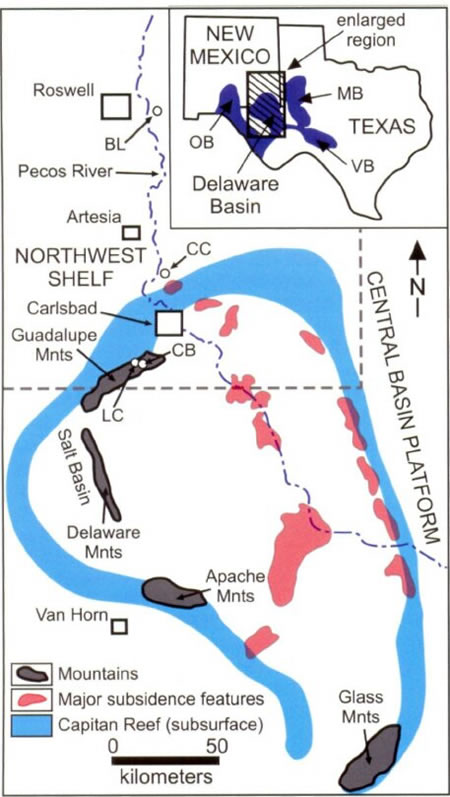
Map of the Delaware Basin. Carlsbad Caverns are "CB" on the map. Image courtesy of Stafford et el., 2009
Following deposition of the Permian Reef, the area was eventually uplifted into the Guadalupe Mountains starting 80 million years ago and accelerating 20-30 million years ago as faulting exposed the once buried reef eventually forming the mountains as we see them today.
.JPG)
While the dissolution of the caverns started prior to the uplifting of the Guadalupe Mountains, it was the faulting and uplift that prompted the major episodes of cave formation.
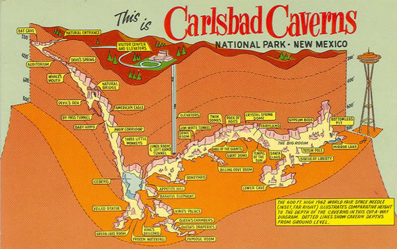
Carlsbad Caverns postcard depicting a map of the caves. Image courtesy of Visit Carlsbad.
Cave systems are typically formed by the slow dissolution of limestone by a weak carbonic acid. The calcium carbonate (CaCO3) that forms the limestone reacts with the weak acid (H2CO3) that forms when rain water reacts with carbon dioxide. This acid will then slowly dissolve the limestone as rain water percolates through the limestone along cracks and fissures working it's way to the underground water table.
.JPG)
This is somewhat different than what happened at Carlsbad Caverns. Here a "very aggressive sulfuric acid bath" played a prominent role in cave formation, dissolving the limestone from the water table upwards. The hydrogen sulfide was the result of the regional petroleum reserves that started leaking into the area an estimated 12 million years ago. These sulfuric acid baths are what created the enormous caverns that are a hallmark of the Carlsbad Cavern system.
.JPG)
The natural entrance to the caves then formed once the sulfuric acid baths had retreated ~one million years ago and erosion and gravity force the the ground surface to start to collapse in. At this point "normal" cave development took place with the formation of typical speleothems occurring
References
http://npshistory.com/publications/geology/state/nm/1987-117/sec7-1.htm
https://www.usgs.gov/geology-and-ecology-of-national-parks/geology-guadalupe-mountains-national-park
http://npshistory.com/publications/cave/nrr-2007-003.pdf
https://www.nps.gov/cave/planyourvisit/upload/cave_geology.pdf
https://carlsbadnewmexico.com/places/carlsbad-caverns-maps/
Visited in 2004
On a separate trip from our trip to Carlsbad Caverns, we hit up White Sands National Park back in 2004. It is hard to not have geologically themed photographs here since the entire park is a geology wonderland.
.JPG)
When you think of "sand", you often think of the gritty, rough grains you find on a beach or in the desert. Sand is actually a size determination. The definition of sand is that it is particles that are from 0.05 to 2.0 mm in diameter. Size of particles go from mud/clay, silt, sand, and gravel. These can further be broken down but that is the general gist of it.
.JPG)
Most beach and desert sands are made of the mineral quartz (SiO2). This is because quartz is a very, very abundant mineral on the surface of the Earth, and it also has some special features that allows it to remain around long enough to become sand. For one, it is a very hard mineral (a 7 out of 10 on the Mohs Hardness Scale below).
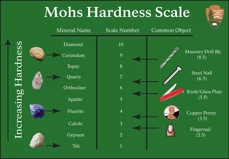
Mohs Hardness Scale showing the relative hardness, or ability to be scratched, of minerals. Minerals shown are the reference minerals and don't cover every mineral on Earth. Image courtesy of the NPS.
Another mineral property that quartz does not have is called cleavage, meaning that the mineral breaks along planes of weakness. Both of these combine means that quartz has a tendency to erode slowly and into tiny little smooth balls, hence sand grains. But these sand grains are also typically gritty feeling because of the hardness of quartz. And even though quartz grains at that scale are clear, tiny amounts of rust (or hematite) dust color the sand grains a pale orange/yellow color.
As is sometimes the case, not all beach and/or desert sands are made of quartz. White Sands is one of those special types of places where the sand dunes are = made up of a completely different mineral. The mineral here is called gypsum (CaSO4.2H2O). As can be seen in Mohs Hardness Scale above, gypsum is by far softer than quartz. So soft in fact that the mineral itself is softer than your fingernails (meaning you can scratch a gypsum crystal with your nail). This creates sand dunes that are very, very soft and quite fun to play in.
.JPG)
Gypsum is an evaporite mineral, meaning that it is often left behind in areas where water evaporation are high. Places like the Great Salt Lake are evaporation basins, where as the water evaporates it leaves behind the salt that had been gathered from the surrounding environment. Depending on the chemistry of the surrounding rocks different evaporative minerals would be left behind in different evaporite basins.
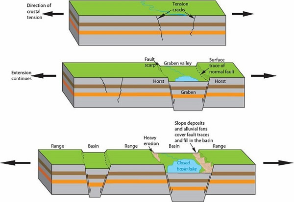
Horst and graben. Image courtesy of the NPS.
The gypsum from which these sand dunes originated first formed back in the Permian (280 to 250 million years ago), when a large shallow sea known as the Permian Sea covered the region. Rising and falling levels produced a large amount of evaporite deposits of the gypsum. These gypsum deposits were then buried over time.
Around 70 million years ago mountain building events, known as the Laramide Orogeny, started to push up the Rocky Mountains, including this region of New Mexico. Around 30 to 10 million years ago the region then started to pull apart. This pull apart created a horst and graben structure, which is where a valley drops down along two sets of faults on either side (pictured above).
.JPG)
The graben here is known as the Tularosa Basin, and is where White Sands NP currently resides. The horsts are the mountain ranges that run along the eastern, the Sacramento Mountains, and western, San Andres mountains (seen here), edges of the basin. These are the bounding mountains which create an enclosed, or end, basin that has no outlet for water. So all water and minerals that get washed into the valley off of the neighboring mountains eventually evaporates away, leaving behind the mineral deposits.
.JPG)
Winds then aid in the transportation of the gypsum across the valley. Since gypsum is a lighter and softer mineral than quartz, lower wind speeds are needed to produce the sand dunes. Ripples, as are seen here, are produced at lower wind speeds with every increasing speeds moving the sand grains up the sides of the dunes, aiding in their movement across the desert.
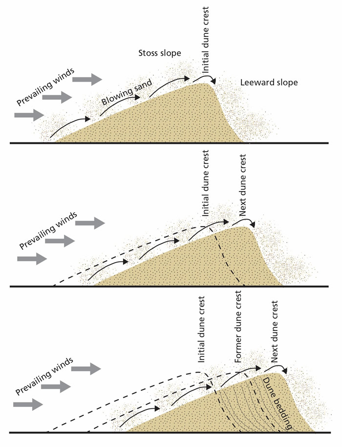
Illustration of how a sand dune moves. Image courtesy of the NPS.
Sand dunes actually move as well. Sand is pushed up one side of the dune, known as the stoss or windward side. And the grains will then drop down the steeper leeward, or slipface, of the dune. As more and more sand grains are moved from the windward side to the slipface side, the dune will appear to migrate in the direct the wind is blowing.
.JPG)
As the dunes move they can actually cross roads, meaning that the roads need to constantly maintained in the park otherwise they would quickly become inundated with sand. The wind's direction during major sandstorms will also rotate steadily clockwise starting from the western direction and dying out as it reverses directions to be from the east.
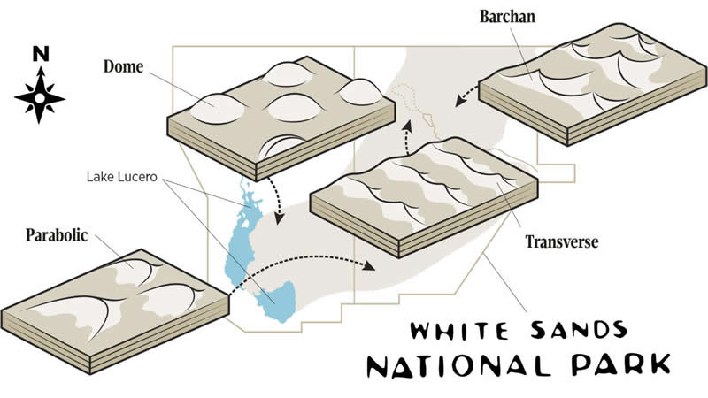
Types of sand dunes found at White Sands NP. Image courtesy of New Mexico Magazine.
Depending on the amount of sand, the local vegetation, topography, and the consistency of wind direction, different types of sand dunes can be produced. The primary types produced in the park are barchan, dome, transverse, and parabolic dunes, as seen in the image above. The shifting wind direction would also shift the direction that the dunes tended to migrate as well.
References
https://www.nps.gov/articles/mohs-hardness-scale.htm
https://www.nps.gov/whsa/learn/geology-of-white-sands.htm
https://geoinfo.nmt.edu/tour/federal/parks/whitesands/geology.html
https://www.nps.gov/articles/horst-and-graben.htm
https://www.newmexicomagazine.org/blog/post/how-sand-dunes-move-at-white-sands-national-park/
