
West Virginia
![]()

Type |
Symbol |
Year Est. |
|---|---|---|
State Rock |
Bituminous Coal |
2009 |
State Gem |
Fossil Coral |
1990 |
State Fossil |
Megalonyx jeffersonii |
2008 |
State Rock: Bituminous Coal
Coal is a type of sedimentary rock that has a very high organic content. It is made up of prehistoric plant material that has slowly been compressed over time forming thin layers ranging from millimetres to several tens of meters thick. The large amount of plant material typically occurred in prehistoric swamps. Over time the plant material died and accumulated in the water. There was so much dead plant material in the water that there wasn't enough oxygen to cause plant decay, leaving the plant material behind to eventually be covered up by sediment as the swamp was slowly transformed into a different environment (i.e. beach, floodplain, lagoon, etc.). Coal is typically composed of mostly all carbon (50-98%), hydrogen (3-13%), and oxygen, with varying amounts of nitrogen, sulphur, and other elements. Because of the high organic content, coal is an ideal combustible and has been used for centuries as a heat and fuel source. There is a range of types of coal depending on how long the plant material has been "cooked", a process that involves compaction of the plant material, how high the temperature had gotten, and how long it was heated for. The type of coal also depends on the original plant materials that had been compacted to form the coal. By degree of cooking the ranks of coal are: peat (essentially pre-coal), lignite (brown coal, low temperature cook, carbon content 60-70%), bituminous ("soft coal" and the most abundant, has a higher temp of cooking, 71-87% carbon), and anthracite (technically a metamorphic variety of coal that has >87% carbon, considered "hard coal").
State Gem: Fossil Coral
Coral is an invertebrate animal that belongs to the group Cnidaria. Cnidaria also includes the well known jelly fish and sea anemones. Corals are a sessile organism, meaning that they live most of their life in one location, mainly rooted to the ocean floor. The coral animal, called a polyp, is a tiny organism that secrets a calcium carbonate "shell" around itself, like a clam. The accumulations of many of these shells is what most people think of when they think of coral. Neighboring polyps also secrete a shell and attached themselves to other polyp shells. This creates an apartment building type complex with tiny animals, each about the size of a nickle, living within each shell all attached to one another. Over time the animals die and new corals attach to the upper surfaces creating new structures. The coral animals themselves actually form a symbiosis with an algae called a zooxanthellae, where the algae creates the food from the sunshine and the corals eat the food. The corals then provide the algae with protection within their shell. Corals are generally found within fairly shallow and warm waters. These waters allow many corals to grow and the algae to create food. Over time the coral skeletons/shells can eventually build up and form a reef.
Related: Florida State Stone - Agatized Coral; Hawaii State Gem - Black Coral; West Virginia State Gem - Fossil Coral
State Fossil: Megalonyx jeffersonii
References
https://statesymbolsusa.org/states/united-states/west-virginia
Geology of West Virginia's National Parks
Through Pictures
(at least the one's I have been to)
Gauley River National Recreation Area
New River Gorge National Park & Preserve
National Parks visited but I have no pictures (at this time) to do a geology post
(link directs to NPS site)
Bluestone National Scenic River (2001)
Gauley River National Recreation Area
Visited in 2001
The first couple of national parks that my future wife and I visited were in West Virginia, hence the reason I don't have many geologically themed photographs. Gauley River National Recreation Area is located within the Appalachian Mountains, much like Shenandoah National Park to the east and the Great Smoky Mountains to the south, so the geological formation of the region would follow a similar path.
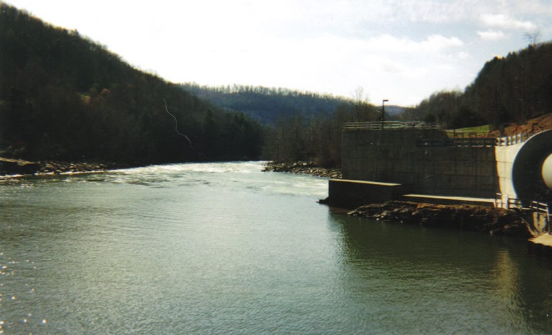
Looking downstream the Gauley River from the Summersville dam
The Gauley River flows from east to west across West Virginia until it eventually meets up with the New River. Within the Gauley River NRA, the river cuts through Lower Pennsylvanian (~320 million years old) New River Formation rocks, specifically the Upper Nuttall Sandstone and some undifferentiated deposits below the Upper Nuttall and above the Upper Raleigh Sandstone.
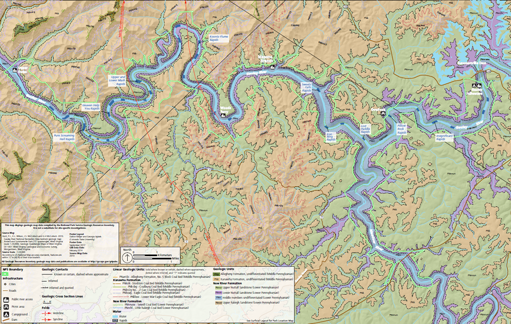
Bedrock Geologic Map of the Gauley River NRA. Image courtesy of the NPS.
The Upper Nuttall Sandstone, along with the rest of the New River Formation, was deposited along the western coastal edge of the Iapetus Ocean as Pangea was slowing being formed and North America and Africa were barreling towards each other. The sandstone deposits themselves represent the beach/barrier island complex of the region. The sandstone layers are mixed with shale layers that are intermingled with several coal seams. These coal seams represent areas where lagoons formed when the barrier islands were located further to the east, allowing abundant live to thrive in a swamp-like environment. The New River Formation is the final gasp of coastal deposits in the area as the ocean fully closed up shortly after this.
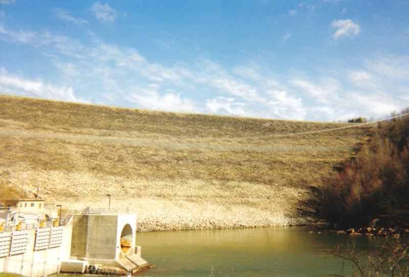
Summersville Dam
The Summersville Dam, seen here, is actually located just upstream of the National Park boundary along the Gauley River, however because of that it has a tremendous impact on the water flow through the park. Dam's have historically not been the best for the environment, completely disrupting the traditional flow of water, sediment, and wildlife that thrives in such an environment. However the construction of such dams also provide a much needed service for the people that live in the region. The construction of the Summersville Dam helps control flooding that was destroying nearby communities as well as provide a renewable source of energy through their hydroelectric plant.
Also, interesting item of note, dams are typically named after the nearest town, however the nearest town was called "Gad" and it was agreed upon that the second closest town's name would be used instead.
References
https://www.summersvillewv.org/city-government/hydro-electric-project/
https://irma.nps.gov/DataStore/Reference/Profile/2250332
https://csmgeo.csm.jmu.edu/geollab/vageol/vahist/LatPalenvir.html
https://summersvillecvb.com/dam
New River Gorge National Park & Preserve
Visited in 2001
Another park that is within the Appalachian Mountains, the New River Gorge has a similar geological history as other nearby parks like Shenandoah National Park to the east and the Great Smoky Mountains to the south. It also traverses some of the same rock types as the Gauley River National Recreation Area a short distance to the north, however since the New River Gorge is much larger and deeper than the Gauley River valley, the rocks exposed are slightly older (although they also overlap).
.jpg)
The New River Gorge cuts through Carboniferous Age deposits from the Upper Mississippian age Bluefield Formation (~325 million years old) up through the Middle Pennsylvanian Allegheny Formation (~312 million years old).
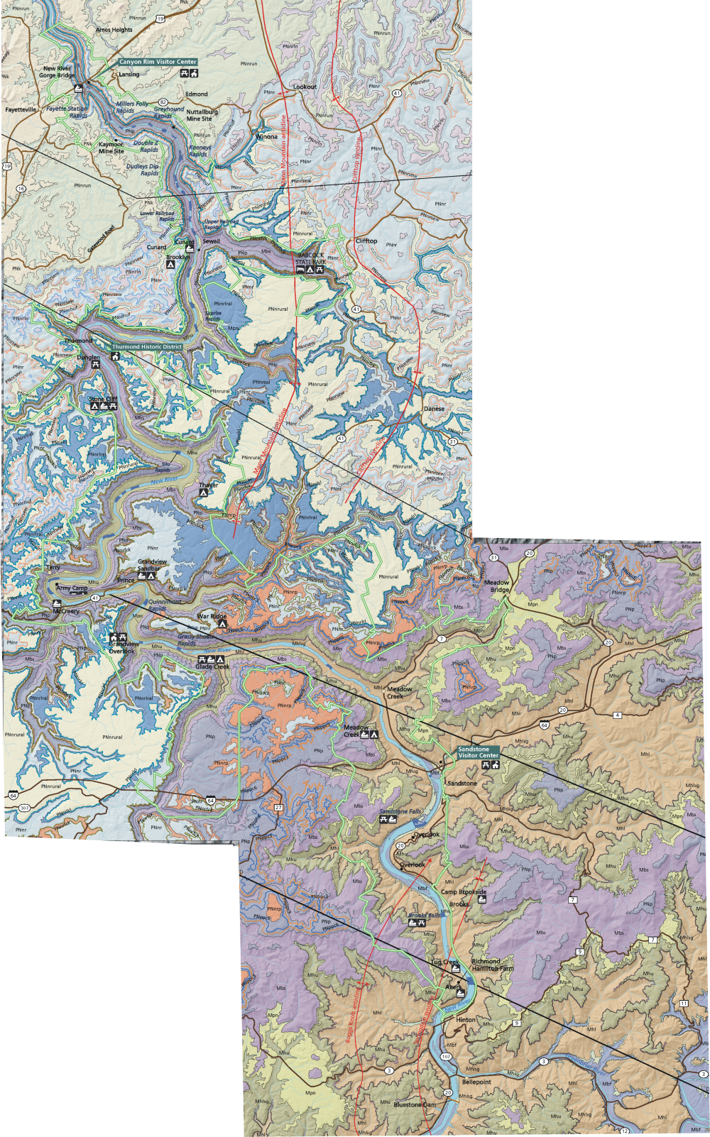
Geology of the New River Gorge National Park & Preserve. Map courtesy of the NPS.
The different formations are groups of rocks made up of members that were deposited in similar environments. Although the water levels fluctuate up and down during this time interval, overall North America is moving towards Africa in this time period as the Iapetus Ocean was closing up towards the east. Eventually North America will meet up with Africa to form the supercontinent Pangea, but we haven't gotten there yet when these rocks were deposited.
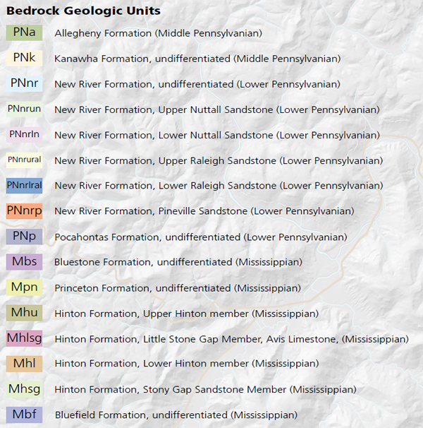
Geological map units for the New River Gorge National Park & Preserve. Courtesy of the NPS.
The rock units here, as well as at Gauley River NRA, dip towards northwest in a direction that essentially follows the course of the river. One of the oldest formations, the Hinton Formation, was deposited along the coast, with both marine and freshwater deposits represented. It is made up of shales and siltstones, with lesser amounts of sandstones and limestones. It gets up to 1,000 feet thick within the gorge.
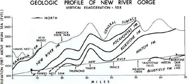
Geologic Profile of the New River Gorge. Image courtesy of WVGES.
Above the Hinton Formation, the Bluestone Formation is what is known as a regressive sequence, where the sea level slowly went downwards until there is a paleosol (ancient soil) deposited before the Pocahontas Formation starts to be deposited. The paleosol represents an unconformity, which is a buried erosional surface, and signifies the transition from the Mississippian to the Pennsylvanian. Above the Pocahontas Formation is the New River Formation, which is partially seen at the Gauley River NRA. This again represents a coastal environment and the last coastal environment deposited within the region.
.jpg)
The New River itself is often designated the "second oldest river in the world," however this is difficult thing to actually determine. We know that the oldest rocks that the New River erodes through are ~310 million years old, so the river must be younger than that.
.jpg)
It is also estimated that the river is at least 3 million years old based on glacial evidence that the New River follows the same course as the pre-glacial Teays River a river that used to flow towards the northwest and eventually was the ancestor to the lower reaches of the Illinois River. The Teays River, and eventually the New River, is the only river to cut across the Appalachian Mountains. This is because it predated the mountains and was able to cut down through them as they were lifted up, much like the Colorado River cutting out the Grand Canyon or the Black Canyon of the Gunnison. Estimates for the age of the New River therefore fluctuate between 3 and 310 million years, quite a variance.
.jpg)
Along the New River Gorge, with the steep sided cliffs due to the abundance of sandstone deposits forming ledges, there are a number of picturesque waterfalls. I believe this is Cathedral Falls, which starts far above me in the picture, tumbling over the New River Formation's Upper Nuttall Sandstone.
.jpg)
But while there are some of the largest waterfalls in West Virginia within the New River Gorge, there are also smaller waterfalls, that flow down many of the shale deposits along the gorge's depth.
.jpg)
References
https://irma.nps.gov/DataStore/Reference/Profile/2251616
https://gsa.confex.com/gsa/2010NE/webprogram/Paper168707.html
https://vtechworks.lib.vt.edu/bitstream/handle/10919/40533/ETDMaynard.pdf?sequence=1
https://www.wvgs.wvnet.edu/www/geology/geoles01.htm
https://www.nps.gov/neri/learn/nature/geology.htm
https://www.nps.gov/neri/learn/nature/geologicformations.htm
