
Iowa
![]()

State Rock: Geode
S.J.R. 20, February 2, 1967
A Joint Resolution designating the Iowa geode as the official state rock for the state of Iowa.
WHEREAS, it is common practice for states to adopt specific flowers, birds, and trees as the official state flowers, state birds, and state trees, and
WHEREAS, it is also the practice among a number of states to adopt certain rocks as the official state rock of the state, and
WHEREAS, the state of Iowa does not at the present time have a rock as the official rock of the state, and
WHEREAS, Iowa has natural deposits of one of the rarest and most beautiful rocks in the example of the Iowa geode, and
WHEREAS, the Iowa geode is a much sought after brightly colored rock of a crystal formation and one of the finest geodes located in the nation, and
WHEREAS, Iowa is one of the few places where the geode formations are plentiful and found in some abundance, and
WHEREAS, a survey conducted through the use of questionnaires mailed to rock collectors in the state has indicated that the Iowa geode is the first choice for the official state rock of Iowa; NOW THEREFORE
Be It Resolved by the General Assembly of the State of Iowa:
Section 1. The Iowa geode is hereby designated and shall hereafter be officially known as the state rock of Iowa.
Sec. 2. The curator of the department of history and archives is hereby directed to obtain samples of the Iowa geode adequate to represent a fair sampling of the rock as found in this state and display the samplings 1n an appropriate place in the state historical library.
Sec. 3. The editor of the Iowa Official Register is hereby directed to include an appropriate picture with an appropriate commentary of the Iowa geode in the Iowa Official Register along with pictures of the state flower, state bird, and state tree.
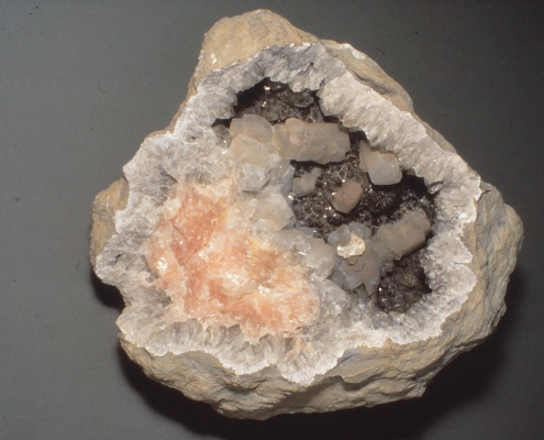
An Iowa Geode. Image courtesy of the Iowa Geological Survey.
A geode is a hollow, or void, that is roughly spherical in shape in a rock in which minerals precipitate, forming (oftentimes) beautiful crystal displays. The voids in which geodes form are commonly found in limestones or volcanic rocks, and, although rarely, other rock varieties. These are then filled with mineral crystals that have slowly grown as water passes through the voids, depositing the minerals molecule by molecule. The minerals crystals are usually quartz (and all its varieties like amethyst) or calcite, but may be found as many other mineral varieties like barite or celestite. One of the notable features of a geode is that they are separable from the rock in which they occur and the crystals are notably different than the surrounding rock, making them more easily collectable than a lot of crystals or minerals that need to be dug out of place.
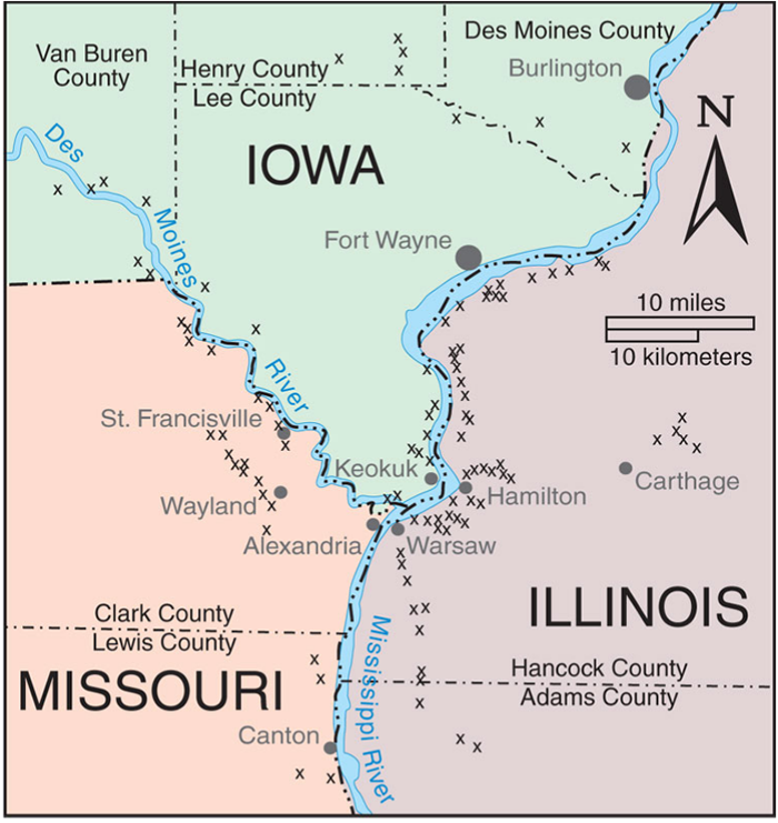
Map of Keokuk Geode localities. Image courtesy of Mindat.org and (C) William W. Besse
The beauty and abundance of the geodes found in Iowa were one of the reasons that they were named the State Rock, where they were even known globally as some of the best geodes on Earth. The identification of them as the State Rock was also to improve tourism with the goal in getting people into the state to go rock hunting. Geodes in Iowa are most notably found in the 35-miles surrounding Keokuk, prompting the name for these geodes, the "Keokuk geodes". Keokuk is found in the southeastern corner of Iowa, near the borders of Illinois and Missouri. These geodes formed in the Mississippian (353.8 - 342.8 Ma) lower Warsaw Formation, which is an amalgamation of shales, shaley dolomites, dolomites, and dolomitic limestones. The geodes are comprised of an outer shell of chalcedony, a microcrystalline variety of quartz. Chalcedony also coats the interior surface of many of the Keokuk geodes, forming a variety of colors including white, pink, grey, blue, yellow, and orange. And while most of the Keokuk geodes contain mainly quartz crystals, calcite is also common, as well as 17 other minerals.
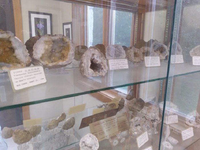
Geode display at Geode State Park. Image courtesy of Onlyinyourstate.com.
There are also many places to find geodes in the area. There is even a state park named after the geodes: Geode State Park, however you are not allowed to collect geodes there. The park offices do have some displays with locally found geodes though. In the surrounding areas, there are many locations that can be found so that you can search for your very own geodes, however collecting should only be done on public land where collecting is approved or on private land with the permission of the landowner.
References
https://iowageologicalsurvey.uiowa.edu/iowa-geology/popular-interest/iowa-geodes
https://publications.iowa.gov/25569/1/2015-10-16_11-10-17_em-43.pdf
https://www.mindat.org/photo-540814.html
https://www.onlyinyourstate.com/iowa/geode-lake-ia/
https://rockhoundresource.com/iowa-rockhounding-location-guide-map/
Geology of Iowa's National Parks
Through Pictures
(at least the one's I have been to)
Effigy Mounds National Monument
Herbert Hoover National Historic Site
Effigy Mounds National Monument
Visited in 2021
.jpeg)
Obligatory entrance sign
.jpeg)
Great Bear Mound
Created by ancestral people known as the Effigy Moundbuilders, the mounds served several different purposes. Primarily they were used for human burial purposes by piling soil, sod, and clay, along with other materials, in the shapes of animals over the bodies of the deceased. These shapes include birds, bears, water spirits, deer, turtles, beaver, buffalo, canines, and other animals, however the shapes are often difficult to identify along when viewed at ground level. The Lidar image below gives an excellent example of an aerial view of the mounds, with each of these marching bear mounds reaching around 20 meters in length.
.jpg)
Lidar of the Marching Bear Group in the southern portion of the park. Image courtesy of the NPS via Wikimedia.
Found throughout the region, most of the mounds within the park are conical in design. However mounds, like the Great Bear Mound, form the shape of animals (pictured from ground level above). There are also linear and compound designs found within the park, but in far fewer numbers.
.jpg)
Types of mounds found at Effigy Mounds NM. Image courtesy of National Park Planner.
The construction of at least some of the mounds began by first removing the sod or leafy humus from the forest floor. A square shaped pit was then dug out and human bodies were laid to rest within the pit. One of the excavated mounds held four bodies. Soil was then piled up upon the bodies along with rocks and clam shells. Cremation ashes mixed with baked reddish clay were mixed in with the final layer of earth on top of the mound.
.jpeg)
The location of the mounds, especially within this region, were generally along elevated surfaces. These mounds, in the picture above, are the end of a linear series of conical mounds that end at a promontory overlooking the Mississippi River (below). By placing the mounds at an elevated location they remained isolated from the flooding common to the shores of the Mississippi River.
.jpeg)
All of the mounds within the park are located upon an elevated plain overlooking the Mississippi River, with tributary rivers, like the Yellow River adjacent to the entrance and Visitor's Center, carving deep valleys within the plateau. The plateau is comprised primarily dolostone (a more weathering resistant variety of limestone) and sandstone. Both provide a surface that is slow to erode away.
.jpeg)
Prairie du Chien Group seen along the hike up to the mound plateau on the northern portion of the park.
Geologically, the mounds sit upon the Lower Ordovician age (~480 million years ago) Oneota and Shakopee Formations, which make up the Prairie du Chien Group. These beds are primarily made up of dolomite, quartz sandstone, and sandy dolomite. There is also significant amounts of chert within the beds. Below the Prairie du Chien Group, you can also see the older, Upper Cambrian in age (~490 million years old), Jordan Sandstone along the parts of the park that border the Yellow River. Both of these formations were deposited when the area was inundated by a vast sea. The sea ebbed and flowed across the land, alternating periods of deep water deposits as well as shallow coastline deposits. When the water was shallower, sand would be deposited along the coastal waters. As the water deepened, limestones and dolostones (a variety of limestone that has a high concentration of magnesium within the crystal structure), were deposited from the bodies of sea life that slowly died over time.
.jpeg)
Glacially, Effigy Mounds is in the Driftless Area of Iowa, meaning that it was never covered with glaciers. While these elevated plateaus did not feel the effects of glacial activity, the neighboring Mississippi River was carved out by glacial meltwaters, with glacial debris filling up the river valley up to 150 feet.
.jpeg)
3 Mounds
While the park is primarily an archeological site, geology plays a major role. By providing the elevated location for the mounds, to suppling the materials used that were incorporated within the mounds, such as the dolostone, clay, along with the soil and sod, geology was a major contributor to the building of the Effigy Mounds.
References
https://www.nps.gov/efmo/learn/nature/geologicformations.htm
https://ngmdb.usgs.gov/Prodesc/proddesc_78247.htm
https://lakeshorepreserve.wisc.edu/native-americans-and-the-preserve/
https://www.nps.gov/efmo/learn/nature/naturalfeaturesandecosystems.htm
https://commons.wikimedia.org/wiki/File:Effigy_mounds_lidar.jpg
Herbert Hoover National Historic Site
Visited in 2021
.jpeg)
Obligatory entrance sign photo
.jpeg)
Herbert Hoover is notably the only geologist (to date) to have become president. His wife, Lou, was also a geologist, and the first woman to receive a geology degree from Stanford University. And while you would hope that a geologist would have many geological tidbits around his National Historic Site, there are not many across the park.
.jpeg)
Schoolhouse
In front of the schoolhouse there is a sign that has a little geological tidbit about Hoover. It is assumed that Hoover attended school here from age 5 until ~10 or 11, after which he went to live in Oregon with his uncle after he was orphaned. Eventually, he attended Stanford and received a degree as a Geological Mining Engineer, with the photo in front of the school house here, showing Hoover as part of a geological survey squad in 1893.
.jpeg)
Herbert Hoover Birthplace Cottage
Another site within the park, the Birthplace cottage, has some geology to it. The foundation of the birthplace cottage had been changed over the years, with the original foundation having been constructed using local boulders found on the prairie. The cottage was then purchased by another family and moved in 1889. However, it was then restored to its original location in 1934, when the Hoover family repurchased it. The stones used for the current foundation is a "local stone", however I can't find any more information on the specific rocks used. My guess is that it is a dolomite (a type of limestone), because the park sits upon several dolomite formations.
.png)
Geological map of Herbert Hoover National Historic Site and surrounding area. Image courtesy of the NPS.
.png)
The majority of the park sits upon the Silurian Age (~430 million years old) Scotch Grove Formation and the ~425 million year old (still Silurian) Gower Formation. Both of these are fossiliferous dolomites that formed in fairly shallow marine environments. These rocks are slightly younger than the bedrock below the nearby Effigy Mounds National Monument. If the stones for the birthplace cottage were quarried locally, it is likely that one of these two formations were the ones quarried.
.jpeg)
One of the most notable geologically related construction stones are the marble slabs used for the grave markers for both President Hoover and his wife, Lou. The marble slabs are noted as "Vermont white marble", however there is little information besides this to identify the quarry, region, or formation of the marble use. It is assumed that, due to the time period that these slabs would have been quarried, and the importance of the memorial (being a former president) that these are likely from the Danby Imperial quarry.
.jpeg)
The Danby quarry is the largest underground marble quarry in the world. This quarry, located in the northeast flank of Dorset Mountain in Vermont, mines the Columbian member of the Lower Ordovician Shelburne Formation (~480 million years ago). These marbles were originally deposited as a limestone within a shallow marine environment. Then burial under other rocks and metamorphism from mountain building heated the limestones up and folded them, altering the minerology to produce the marbles as they are today. Blocks of marble from this quarry have been used in the New York Public Library, the Jefferson Memorial, Harvard Medical School, the U.S. Senate Building, Arlington National Amphitheater, the Supreme Court, and the United Nations building.
.jpeg)
Although it is possible to find some of the bedrock along local stream channels, the majority of the bedrock within the park is located fairly deeply beneath glacial sediments (hence the original boulders used for the birthplace foundation) that were deposited during the early and middle Pleistocene Epoch (about 2.6 million years ago to 500,000 years ago). These glacial deposits are known as the Pre-Illinoian Alburnett and Wolf Creek formations, which comprise mostly of till, a glacial deposit that is essentially a clay rich mishmash of everything that can be thrown into one pile. Think of a glacier scouring the surface of the earth and then just dumping everything it picks up into a pile like a conveyor belt. That is till.
References
https://whittiermuseum.org/research/lou-henry-hoover/
https://www.nps.gov/articles/nps-geodiversity-atlas-herbert-hoover-national-historic-site-iowa.htm
https://npshistory.com/publications/heho/nrr-2017-1479.pdf
https://www.vermontdanbymarble.com/home-5-7-4/
https://dec.vermont.gov/geological-survey/resources-energy/minres/marble
https://craftsmanship.net/sidebar/dorset-marble-quarry/
https://irma.nps.gov/DataStore/Reference/Profile/2250366
https://igs.iihr.uiowa.edu/igs/publications/uploads/ofm-2011-04.pdf